How drop cameras, quadrats and towed video work with live preview
Benthic habitats are the communities living on and in the seafloor: seagrass meadows, rocky reef, kelp, sponge gardens, shellfish beds and soft sediment. A benthic habitat survey maps and monitors these areas, showing researchers, managers and community groups how coastal ecosystems are changing over time.
Underwater video is one of the most common survey tools, because it is non-destructive and gives a permanent record of what was there. The challenge has always been knowing what the camera is actually recording until you bring it back up.
Common benthic habitat survey methods
Drop camera surveys
A camera is lowered from a boat to the seafloor at set sites, records for a fixed time or captures stills, then is retrieved. It suits point sampling across a grid or along depth gradients, and works from a small vessel.
Quadrat surveys
A camera is mounted to a square frame of known size and placed on the seabed. The frame gives consistent scale for estimating percentage cover, density and species composition.
Towed video transects
A camera is towed slowly behind a boat along a set line, recording a continuous strip of seafloor. This covers more ground than point sampling and is used to map habitat boundaries, such as where seagrass gives way to sand or reef.
Diver transects
Divers swim set lines recording habitat by camera or on slates. Accurate, but limited by depth, bottom time and diver availability.
Why live preview changes the survey
With a standard drop or towed camera, you only find out whether the footage is usable after retrieval. Murky water, a camera facing the wrong way, a frame landing on its side or a rig flying too high off the bottom all mean wasted deployments.
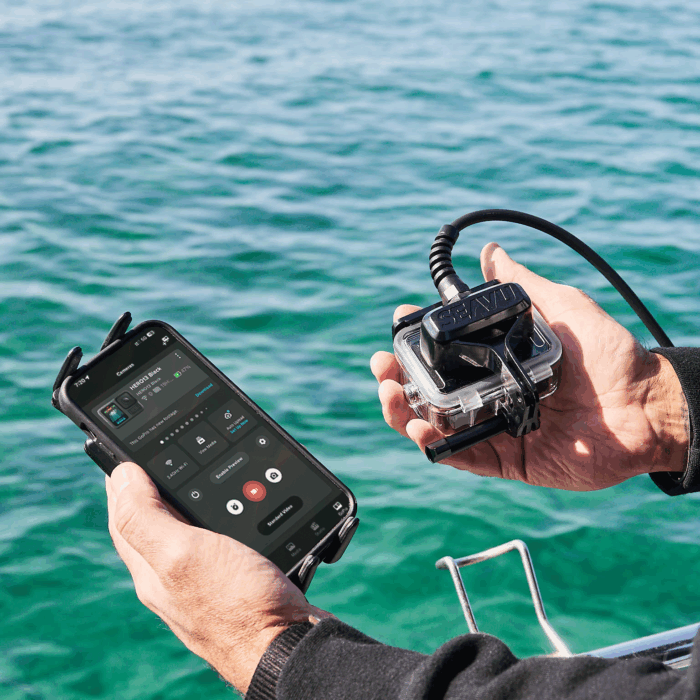
Live preview on a phone or tablet at the surface lets you:
- Confirm the camera is on the seabed and facing the right way before recording
- Adjust height off the bottom during a tow to keep the field of view consistent
- Check visibility and lighting on the spot and decide whether to continue
- Note habitat changes as they happen and mark positions in real time
- Reduce redeployments and get more usable sites per day
Seeker Marine Kit: the drop camera and quadrat setup
The Seeker Marine Kit turns a GoPro or DJI action camera into a live drop camera. A unit near the camera captures its WiFi and Bluetooth signal underwater, a dedicated Seavu cable carries it to the surface, and it is then sent wirelessly to your phone or tablet. You view, control and record through the GoPro Quik or DJI Mimo app, with no internet connection needed.
Watch: how Seavu works
Cable lengths are 7m, 17m, 27m and 52m. The camera needs a compatible waterproof case, and maximum cable length depends on the camera model. Check the recommended cameras guide before choosing a cable.
For quadrat work, the Seeker attaches to a standard GoPro mount, so it can fit existing frames without modification.
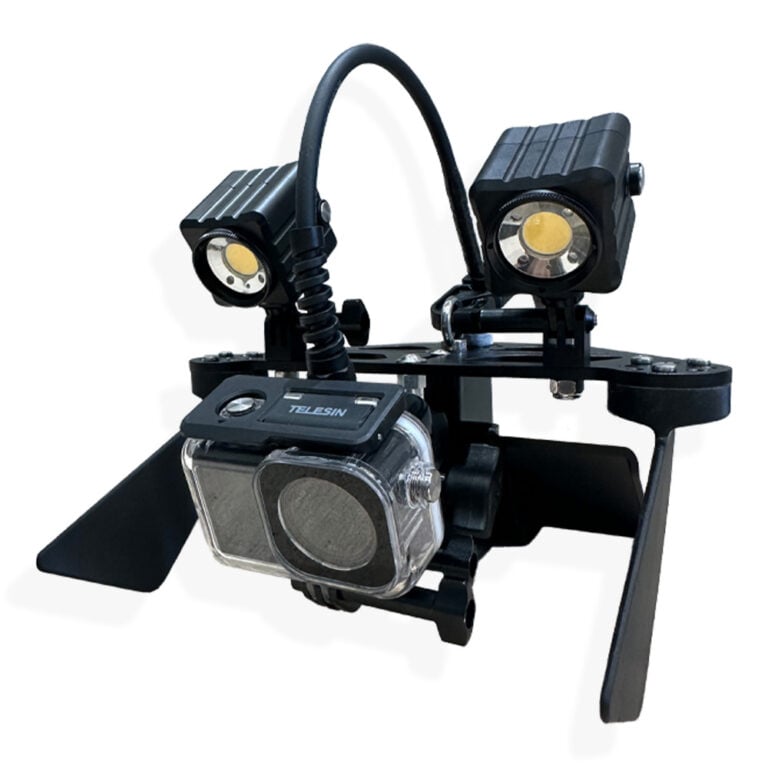
For drop camera or quadrat work at low light sites, the Seeker Pro Lights include a mounting arm with a GoPro-style mount underneath and positions for both lights and the Seeker on top, so the whole setup attaches as one unit.
Seeker DeepScope Rig: towed video transects
The Seeker DeepScope Rig is an attachment for the Seeker Marine Kit that turns it into a towed survey platform. Its weighted hydroplane design, streamlined tray and twin stabilising fins keep the camera steady while moving through the water.
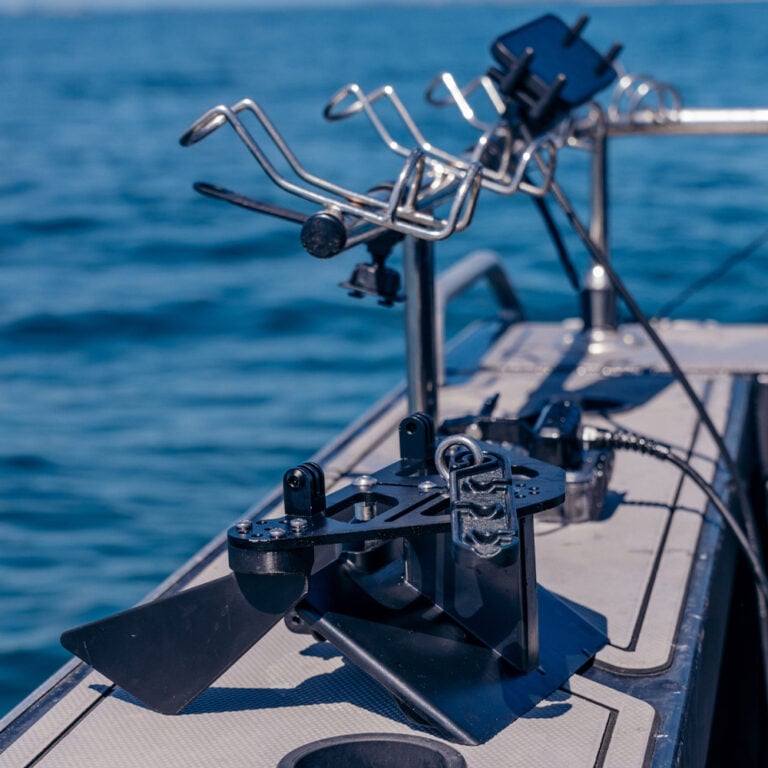
The camera mount adjusts to look down, forward, back or up. For benthic work, a downward or forward-angled view is typical.
Watch: how the Seeker DeepScope Rig works
Towing speed
The rig works at up to 3 knots, but performs best between 0.5 and 1 knot. Around 0.5 knot gives the sharpest, most stable picture with minimal disturbance to sediment. Around 1 knot gives efficient coverage while keeping footage clear.
Typical operating depths
| Cable | 0.5 knot | 1 knot | 2 knots |
|---|---|---|---|
| 7m | 4m | 3m | 2m |
| 17m | 14m | 11m | 9m |
| 27m | 24m | 18m | 15m |
| 52m | 48m | 37m | 31m |
Estimates allow 2m of cable at the surface. Actual depth varies with current and sea conditions.
Low light
For deeper or turbid sites, the Seeker Pro Lights mount directly to the DeepScope Rig. Each light gives 3000 lumens with a wide 120° beam, and adjustable mounts let you angle the light evenly across the seafloor. They are waterproof to 60m.
Choosing a setup
- Point sampling at set sites: Seeker Marine Kit as a drop camera
- Percentage cover and density: Seeker Marine Kit on a quadrat frame
- Mapping habitat extent and boundaries: Seeker Marine Kit with DeepScope Rig
- Deeper or low visibility sites: add Seeker Pro Lights
Both setups are compact, run on the camera and phone or tablet batteries, and deploy from a small boat rather than needing a large research vessel.
Recording position with GPS
Footage is only useful for mapping if you know where it was taken. GPS signal does not travel through water, but you can still use it at the surface to anchor each recording to a location.
Using the camera’s GPS
If your camera has built-in GPS, start recording at the surface before deployment and keep it running until after retrieval. The camera logs its position while above water, giving you GPS points for both the deployment and retrieval locations in the footage file.
Syncing with onboard GPS
Set the camera’s date and time to match the boat’s GPS before heading out. This lets you line up the camera’s deployment and retrieval points with the boat’s track or waypoints, and cross-check positions between the two.
Towed transects
Run a GPS track on the boat for the whole tow. The camera’s start and end points, plus the boat’s track and timestamps, give you the path covered along the seafloor.
With live preview, you can also note habitat changes as you see them, such as a seagrass edge or reef boundary, and mark a waypoint on the boat’s GPS at that exact moment.
For towed work, the camera sits behind and below the boat, so positions along the transect will be slightly offset from the true seabed position. For most habitat mapping this is acceptable, but note cable length and speed if higher accuracy is needed.
Who uses it
- Seagrass and reef monitoring programs
- Marine park and fisheries habitat assessments
- Environmental consultants doing baseline and impact surveys
- Universities and student field programs
- Citizen science and community reef groups
Related reading
- Seeing Seagrass in Real Time: How Researchers Use Seavu for Marine Habitat Studies
- BRUV Explained: Baited Remote Underwater Video and How Live View Improves It
Explore the Seeker Marine Kit, Seeker DeepScope Rig and Seeker Pro Lights to set up your benthic survey workflow.